2.16.2013

Constructing | Drawing | Notating

Perry Kulpers

Moving ahead for the next week, we will be making a series of layered, constructed, notational drawings. The primary impulse in these drawings are basic and programmatic: to begin to visualize how to reconnect the river with its flood-plane and how to reconnect people with the river. Representing complex systems that recover time and expand space is a fundamental challenge of the landscape architect, and these drawings can be seen as one step in developing a robust representational toolkit. These drawings are also the first step towards proposing new strategies for farms, houses, industry, and recreation to address the increasing frequency of high water inundation.

We will be using sheets of mylar as the primary substrate for these drawings. Mylar has certain qualities of translucency, surficiality, and depth that can be used to suggest distance or proximity in space and time. Layering behind, building up, cutting through, drawing upon--all of these actions can have suggested meanings in your constructs. Using the analytic maps generated through GIS, aerial photos, and your own drafted notation, you will be making a series of drawings that begin to represent the temporal aspects of your research and ideas.


Lackey

What you will need:
•18x24 mylar sheets (x5)
•choose a meaningful portion of your analysis and zoom/crop/print
•for the same area, print-out an aerial at the exact same scale using the high-resolution aerials available on the GIS server
•cutting materials (blades, scissors, etc)
•drafting materials (pens, pencils, scale, square, compass, etc)
•glue-stick & spray mount
•additional colored paper (canson sheets recommended--in two or three hues of the same color)

We will be working in class Wednesday and Friday constructing a series of plan and section drawings. For Wednesday, please come ready to work with all materials and printouts (i suggest using the high quality plotter for this).

In constructing your plans, think about the surface of the mylar in relation to time--for example: in front of = the present; behind = the past; behind but cut through and revealed = the future; upon =  movement. Or you could think of the surface of the mylar in terms of flood stages--with layers and sub-layers denoting low, normal, and high water stages. Coding your drawing in this way can be a tectonic way of constructing a drawing.

For your sections, take your plan for a walk. Using the techniques we developed during our field surveying session, construct a transect through your plan drawing by simulating and notating the two-tape method. This is similar to drawing a single section line through your plan, but in this case you are thinking more specifically about the actual path the section will take. Translating this to its own drawing, use a similar layering technique to represent density, lightness, swampiness, and continuity.

Overall, these should be worked drawings; constructed drawings, suggestive drawings. They allow you to begin to think about ideas of flow, inundation, connectivity, time, and qualities of place without being tied to your screen. Through their abstraction, they form a key link between analysis and design.
Penelope Haralabidou


2.06.2013

Quarries, Dikes, and Ferries

Rock City Complex, Valmeyer, IL
Outstanding adventure this weekend! I imagine that scampering around the levees, digging into the bluffs, and walking the margins of the river all give you an added sense of the materiality and textures of this thing we call the American Bottom. Bring your insights into your drawings! Into your models! They can now be infused with much more specificity. Reading the landscape and writing the landscape--these are the basic competencies of a designer.
Cold Storage. -20F

Conference Room, Rock City

Wing Dike

Ferry Landing

1.29.2013

Model Thinking

Antoni Gaudi

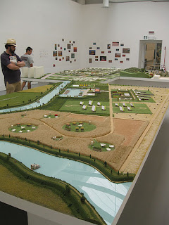
As we consider adding model-making to our conversation and repertoire, here a just a few examples of modeling techniques to get ideas moving. Keep in mind that we will be constructing a group model as well as a series of individual models throughout the semester. Things to think about when discussing the group site model include: scale, ability to add/subtract elements so individual schemes can be inserted, materiality, basic method (stacked contour? casting? foam with bondo? sections?). These sundry techniques all speak to different attitudes about the site, about the audience, and about relation to representation. I will be showing additional examples throughout the semester, but now is a good time to begin to fill in your mental library of model making ideas.
Bartlett Students

Morphosis
Biennale Model
Rhino Model

Morphosis


1.25.2013

A few examples


Below are a few links/titles that I think might be useful in thinking about both the idea of landscape rules as well as in formulating thoughts and ideas about how a users-guide to the AmBot might come together.

Interboro: The Grid, a Users-Guide
[Georgeen Theodore, a partner in Interboro and Professor at NJIT, will be giving a lecture at WashU on February 11th and you may have the opportunity to talk with her about our studio research]

Alex Lehnerer: Grand Urban Rules

Atelier Bow-Wow: Made in Tokyo and Pet Architecture

Keller Easterling: American Town Plans

I will put my personal copies of these books on reserve when they arrive in a few days--in the meantime, I suggest you browse online to get a sense of their content.

1.24.2013

Rules and Steering Regimes

As you move ahead in your thematic research for Friday and Monday, I ask that you consider the various unspoken rules and steering regimes that give the landscape form. These rules may or may not conform the actual regulations that are written down somewhere, but every landscape has its deep set of unspoken rules that guide its development. In thinking about this, be loose. Don't try to come up with absolute rules that apply absolutely everywhere. After all, as the fatigued saying goes, rules were meant to be broken. So what are the unwritten rules that underlay some aspects of your research? Be playful and be persuasive. This is about building an argument, not about finding universal truths. For a quick conversation on Friday after our site visit, please come with a minimum of one rule, typed out in 24pt font, with a single, line diagram that explains the underlying idea. Use notation, lineweight, etc. to build your argument. Remember, as a start this is about rhetoric, about story telling, not accuracy to some notion of truth.
For Monday, in addition to continuing your thematic research on 11x17 pages, I would like you all to work together to produce a single, 6+ foot long drawing of the American Bottom incorporating pieces from each group's research. My only request is that all information be in vector form--no raster files or aerial imagery.

Information Density

From Edward Tufte
As we discussed in class, the density of information, its legibility at a variety of distances, and its incorporation of expanded spatial and temporal scales, is an essential consideration in research of this type. Below are a few resources for thinking about how you might approach displaying complex information:
Edward Tufte. Visual Display of Quantitative Information
Edward Tufte. Envisioning Information
You may also want to look at the following books on reserve for some inspiration:
Smout/Allen. Pamphlet Architecture 30: Augmented Landscapes
Mathur & da Cuhna. Mississippi Floods.

Perry Kulper

USACE

We will be meeting at the US Army Corps of Engineers main office tomorrow at 1:30. 1222 Spruce St, at the corner of Turner and Spruce. There is parking around the area but you will either need quarters for meters or money for a lot. As mentioned in class, we will be meeting with Michael Sonny Trimble of the Curation/Archeological Center for Expertise. Please bring two forms of photo ID.


1.22.2013

The Becoming Landscape || The Becoming Building

Becoming Shed. Near Prairie du Rocher

The interface between floodplane and bluff in the American Bottom is a menagerie of landscape and architectural types that borrow from the intelligence of both--creating a hybrid typology that is not wholly of the landscape nor wholly of the structure. This shed, and the National Archives Record Administration building below, are just a few of the ways this edge condition is inhabited.
NARA. Valmeyer, IL

1.19.2013

Dredging, Blasting, and Scraping

Offices of JB Marine, now on dry land: from NYT
News of drought-related navigation and the efforts of the CoE to keep the river open remain in the news. An article here from the New York Times. It has taken a massive engineering effort of dredging the navigation channel, blasting known rock outcropping, and scraping along both, to keep the river at the 9' navigation depth we discussed on our tour yesterday. This rule--that the CoE must maintain a 9' channel--is the single most important legal directive that has given the agency a green-light to conduct almost any sort of ravaging to the rivers bottom. This article reads well with the previous NYT article we read for our first class. It is, to put it glibly, a "game of inches", that, despite this immediate spate of optimism, will continue to be part of the river discourse for years to come.

1.18.2013

Riverlands

Eight Cubic Meters of Designer
Thank you all for the engaged, curious, and thoughtful questions today. I look forward to discussing further on Wednesday.

The American Bottom Operating System

Roman Operating System: from Mutations, OMA

After our initial introduction to the rivers and its systems today, and as we move into the long weekend, here are the landscape categories for each team (of 2) to dive into:

•levees, river training structures, wharves, access points
•wetlands, conservation areas, open space, physical geography
•industrial land use, agricultural practices
•urban patterns, residential types, ex-urban developments
•the river itself, broader regional influences, watersheds, etc

We will be working toward a Users-Guide to The American Bottom; so historical, contemporary, and proposed data will all be helpful in forming the background information for the handbook.

For Wednesday, each group should come with the following deliverables at minimum (all 11x17):

•site plan diagram explaining current conditions
•site plan diagram charting changes/phases over history
•sectional diagrams explaining how elements/types/systems work within theme
•single, cropped aerial image of a moment that best illustrates tensions/intentions of your theme
•expository axonometric diagram of the same spot chosen for aerial

The diagrams should be drawn with an eye toward legibility--so things like line-weight, color, fill, text, etc, as well as what is included and what is excluded from the drawing, should all be selected accordingly and intentionally. We will talk about both the information as well as about how it is displayed. In addition, print out all pertinent documents that contribute to your analysis and bind together for reference throughout the semester.

1.17.2013

Systems and Types


Bernd and Hilla Becher: Anonymous Sculpture

Much of our research and design work this semester will be systemic and typological. Consider the following as you conduct preliminary research for tomorrow and beyond:

Systems
By focusing on systems, we highlight the connectivity of a given site with the broader ecological conditions, economic forces, and urban patterns that contribute to the textures of a place. So, for example, when we stand at the Lock and Dam tomorrow, you might ask yourself (and hopefully have already somewhat looked into this):
•Where is this water coming from? Sounds obvious, but really, where is it coming from? North Dakota? Chicago? What is the watershed we are dealing with here at this one spot?
•We are at lock #26. Is there a lock 25? 24? 1? 0?
•If there is a barge passing through, what is in the barge? Where is it coming from? What does it connect up with? Extractive industries in Minnesota? Agriculture in Nebraska?
Type
By focusing on type, we highlight the tensions between specificity and generality--between what makes a landscape/infrastructural element both responsive to its immediate context as well as part of a family of design decisions.
•What are the categories of elements? Weir? Dam? Bank? Levee? Parking lot? Wetlands?

•What are the recognizable forms? Shape? Elements?
•How does it work? Why does it work in the way it does? And when does it cease to work--i.e. when does it fail? Limit conditions.
•What are their orientation? To the immediate site and to fundamentals like north-slopes, south-slopes, river-side, land-side?

These are just some suggestions of the questions and categories that could guide your research, thinking, and inquiry as we visit these sites tomorrow and beyond. I ask that you consider how you might best represent these things--both systems and types--through diagrams and photography on the site.

1.15.2013

The American Bottom

Prairie Du Pont Levee
Throughout this semester, this blog will serve as a clearinghouse for thoughts, musings, images, links, and arguments as they relate to our studio work. Please use liberally, and often.